
الأرصاد: إطلاق أولى خرائط الأمطار التاريخية المعتمدة على بيانات الأقمار الصناعية – أخبار السعودية
أعلن المركز الوطني للأرصاد عن إطلاق خدمة متقدمة لتوفير البيانات المناخية طويلة المدى المعتمدة على الأقمار الصناعية، في إطار جهوده المستمرة لتطوير قدرات الرصد والتحليل المناخي وتعزيز منظومة الإنذار المبكر.
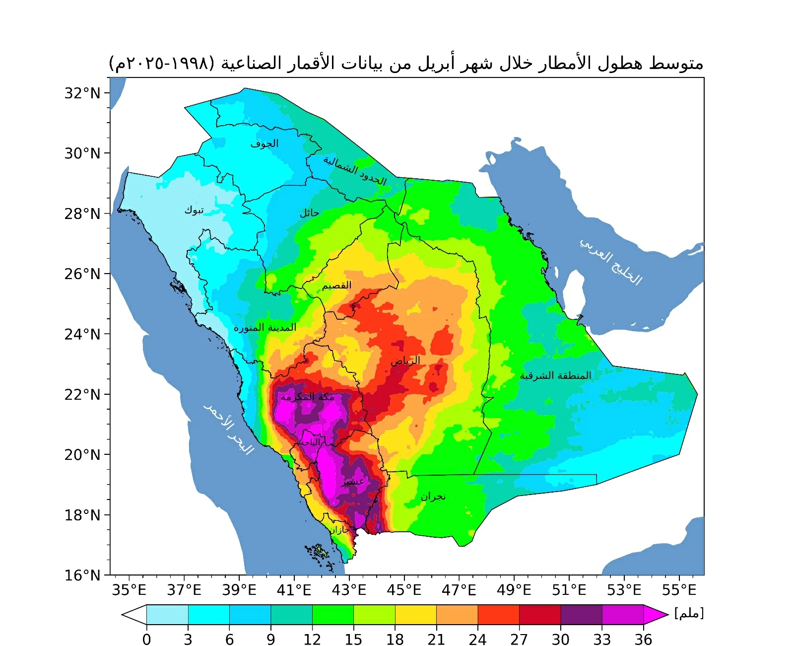
وفي هذا السياق، بدأ المركز بإصدار خرائط مناخية متخصصة تُعنى بتوزيعات هطول الأمطار، حيث أصدر خارطة لشهر أبريل تغطي الفترة الممتدة من عام 1998 حتى 2025، مستندًا إلى تحليل دقيق لبيانات الأقمار الصناعية.
وتُظهر الخارطة تركز كميات الأمطار خلال شهر أبريل بشكل أكبر على المرتفعات الجنوبية الغربية والغربية من المملكة، مع امتدادات أقل نحو المناطق الوسطى، فيما تتوزع الهطولات المطرية بدرجات متفاوتة على بقية المناطق.
وتُعد هذه الخرائط أداة فعّالة في دعم منظومة الإنذار المبكر، إذ تُمكّن الجهات المعنية من اتخاذ التدابير الاحترازية بشكل استباقي، وتعزز من مستوى الجاهزية للتعامل مع الحالات الجوية المختلفة بكفاءة عالية.
وتأتي هذه المبادرة ضمن التوجهات الإستراتيجية للمركز نحو تقديم منتجات مناخية متقدمة قائمة على بيانات دقيقة وتحليلات علمية موثوقة، بما يسهم في دعم عملية اتخاذ القرار ورفع مستويات السلامة العامة.
The National Center of Meteorology announced the launch of an advanced service to provide long-term climate data based on satellite imagery, as part of its ongoing efforts to develop climate monitoring and analysis capabilities and enhance the early warning system.
In this context, the center has begun issuing specialized climate maps focusing on rainfall distributions, having released a map for April covering the period from 1998 to 2025, based on a precise analysis of satellite data.
The map shows that rainfall amounts during April are more concentrated in the southwestern and western highlands of the Kingdom, with lesser extensions towards the central regions, while rainfall is distributed to varying degrees across the remaining areas.
These maps are an effective tool in supporting the early warning system, as they enable relevant authorities to take precautionary measures proactively and enhance readiness to deal with various weather conditions efficiently.
This initiative is part of the strategic directions of the center towards providing advanced climate products based on accurate data and reliable scientific analyses, contributing to supporting decision-making processes and raising levels of public safety.
للمزيد من المقالات
اضغط هنا