
لتعزيز الإنذار المبكر.. «الأرصاد» يبدأ إصدار خرائط مناخية لتوزيعات الأمطار – أخبار السعودية
كشف المركز الوطني للأرصاد بدء إصدار خرائط مناخية متخصصة لتوزيعات الأمطار، ضمن جهوده الرامية إلى تطوير أدوات الرصد والتحليل المناخي، وتعزيز منظومة الإنذار المبكر.
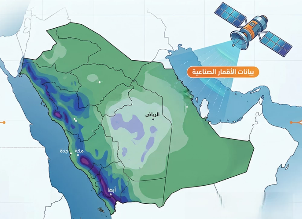
وأصدر المركز في هذا الإطار خريطة مناخية لتوزيعات الأمطار لشهر أبريل للفترة التاريخية (1998 – 2025)، بالاعتماد على بيانات الأقمار الصناعية التي يقوم بتحليلها.
وتُبيّن الخريطة تركز هطول الأمطار بكميات أعلى خلال شهر أبريل على المرتفعات الجنوبية الغربية والغربية من المملكة، مع امتدادها بكميات أقل نحو أجزاء من وسط المملكة، في حين تشهد بقية المناطق هطولات مطرية بدرجات متفاوتة.
وتُعد هذه الخرائط المناخية إحدى الأدوات الفاعلة والداعمة لمنظومة الإنذار المبكر، بما يمكّن الجهات ذات العلاقة من اتخاذ الاحتياطات والتدابير الاستباقية للتعامل مع الحالات المطرية، ويسهم في رفع مستوى الجاهزية والتعامل الفعال مع مختلف الظواهر الجوية.
وتأتي هذه الخطوة تماشيًا مع توجهات المركز الإستراتيجية لتوفير منتجات مناخية متقدمة مبنية على أدق البيانات والتحليلات العلمية، بما يدعم اتخاذ القرار ويعزز مستويات السلامة العامة.
The National Center of Meteorology has revealed the start of issuing specialized climate maps for rainfall distributions, as part of its efforts to develop tools for climate monitoring and analysis, and to enhance the early warning system.
In this context, the center has issued a climate map for rainfall distributions for the month of April for the historical period (1998 – 2025), relying on satellite data that it analyzes.
The map shows that rainfall is concentrated in higher amounts during the month of April in the southwestern and western highlands of the Kingdom, extending with lesser amounts towards parts of central Saudi Arabia, while the rest of the regions experience varying degrees of rainfall.
These climate maps are considered one of the effective tools supporting the early warning system, enabling relevant authorities to take precautions and proactive measures to deal with rainy conditions, and contributing to raising the level of readiness and effective response to various weather phenomena.
This step comes in line with the center’s strategic directions to provide advanced climate products based on the most accurate data and scientific analyses, supporting decision-making and enhancing public safety levels.
للمزيد من المقالات
اضغط هنا